Ted -
Lots of good work there. I'll have to download to study in detail but a couple of quick observations.
The 1844-45 Central National Highway was surveyed from Dallas to the mouth of the Kiamitia on Red River and like the Military Road was not immediately built.
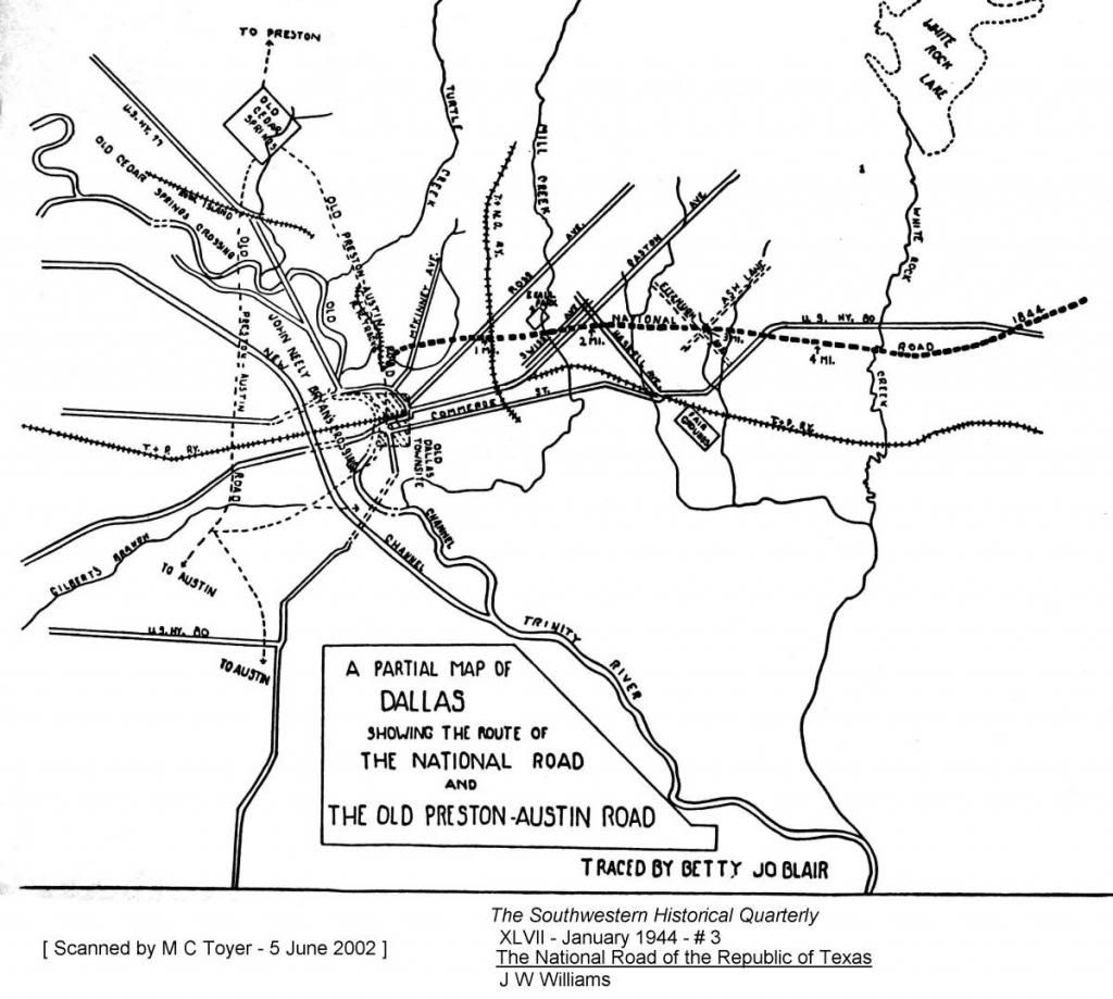
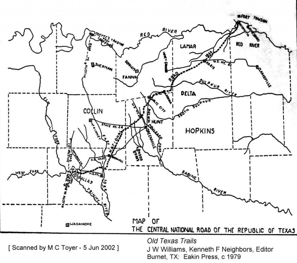
But, unlike the Military Road, the original survey notes survive and have been plotted with a great deal of accuracy. These maps aren't highly detailed but give a general idea:
![]()
![]()
The SWHQ article and book cited in the photo credits have the specific details of the survey notes and correlation to existing sites on the original route.
The route ran almost due east from Dallas, dipping south of later US 80 and crossing the East Fork before turning almost due north toward Rockwall. The route you have depicted aligns more closely with State Highway 1 and the trans-national Bankhead Highway from about 1921. It became SH 66 after US 67 was constructed farther east. There used to be a DAR Historical Marker at the White Rock spillway incorrectly proclaiming that was the CNH. Garland was not on the CNH but was on the Bankhead.
There were a number of early small scattered settlements along the center route you've drawn, roughly following the MKT and later SH 5 and US 75, but I do not think there was a single artery connecting them all before the railroad was built in 1873.
In the early 1840s the mail route ran west from Fort Inglish to about the Military Road then turned southwest to Birds Fort, a route somewhat similar to part of the new SH 161. The other early mail routes can better define the main trails than the later railroads and present highways.
Am pretty sure Colbert was still running the ferry at Preston until the 1850s. That was to be the original crossing point for the Butterfield and the original schedules reflect that but Colbert won the franchise for his new ferry north of present Denison by agreeing to pave the road south.
The old Sherman to Whitesboro Road which was the Butterfield route still exists a bit north of present SH 56.
The relatively short-lived Shawnee Cattle Trail always followed the Military Road / Preston Trail deviating a bit eastward before reaching Little Mineral Creek to approach the river through the natural chute which still exists. The historical marker in Pottsboro is not on the route but the one by the Shawnee Trail School in Plano is.
The old Dallas to Fort Worth Road (ca 1850 - 1876) did branch off the Dallas to Austin Road about where depicted but crossed Mountain Creek near present Kiest and the Toll Bridge continuing westward generally along present 303 and/or Pioneer through Johnson Station before turning northwesterly to Fort Worth. Grand Prairie and Arlington were established along the T&P RR which built west from Eagle Ford to Fort Worth in 1876 and the later Dallas Fort Worth pike and ca 1905-1933 Interurban generally followed the rails.
There was a pretty good book written about 10 years ago, El Camino Del Norte, which examined the various towns, camps and water holes along the route that became US 35, which is the general route of the disbanded Military Road expedition from the Trinity back to Austin in May 1841 - the unobstructed ridge route. The trip north in 1840 was severely hampered by holding too close to the rivers and having to cross the many tributaries and cut through thick bottom land. Unfortunately the author comes up short on the route from Dallas to Preston.
The most detailed map showing the early trails is the 1852 Hedgcoxe / Peters Colony and you can pretty easily match them to current locations by the original survey lines. It covers most of the area of your map from Dallas to Red River.
M C
Lots of good work there. I'll have to download to study in detail but a couple of quick observations.
The 1844-45 Central National Highway was surveyed from Dallas to the mouth of the Kiamitia on Red River and like the Military Road was not immediately built.
But, unlike the Military Road, the original survey notes survive and have been plotted with a great deal of accuracy. These maps aren't highly detailed but give a general idea:
The SWHQ article and book cited in the photo credits have the specific details of the survey notes and correlation to existing sites on the original route.
The route ran almost due east from Dallas, dipping south of later US 80 and crossing the East Fork before turning almost due north toward Rockwall. The route you have depicted aligns more closely with State Highway 1 and the trans-national Bankhead Highway from about 1921. It became SH 66 after US 67 was constructed farther east. There used to be a DAR Historical Marker at the White Rock spillway incorrectly proclaiming that was the CNH. Garland was not on the CNH but was on the Bankhead.
There were a number of early small scattered settlements along the center route you've drawn, roughly following the MKT and later SH 5 and US 75, but I do not think there was a single artery connecting them all before the railroad was built in 1873.
In the early 1840s the mail route ran west from Fort Inglish to about the Military Road then turned southwest to Birds Fort, a route somewhat similar to part of the new SH 161. The other early mail routes can better define the main trails than the later railroads and present highways.
Am pretty sure Colbert was still running the ferry at Preston until the 1850s. That was to be the original crossing point for the Butterfield and the original schedules reflect that but Colbert won the franchise for his new ferry north of present Denison by agreeing to pave the road south.
The old Sherman to Whitesboro Road which was the Butterfield route still exists a bit north of present SH 56.
The relatively short-lived Shawnee Cattle Trail always followed the Military Road / Preston Trail deviating a bit eastward before reaching Little Mineral Creek to approach the river through the natural chute which still exists. The historical marker in Pottsboro is not on the route but the one by the Shawnee Trail School in Plano is.
The old Dallas to Fort Worth Road (ca 1850 - 1876) did branch off the Dallas to Austin Road about where depicted but crossed Mountain Creek near present Kiest and the Toll Bridge continuing westward generally along present 303 and/or Pioneer through Johnson Station before turning northwesterly to Fort Worth. Grand Prairie and Arlington were established along the T&P RR which built west from Eagle Ford to Fort Worth in 1876 and the later Dallas Fort Worth pike and ca 1905-1933 Interurban generally followed the rails.
There was a pretty good book written about 10 years ago, El Camino Del Norte, which examined the various towns, camps and water holes along the route that became US 35, which is the general route of the disbanded Military Road expedition from the Trinity back to Austin in May 1841 - the unobstructed ridge route. The trip north in 1840 was severely hampered by holding too close to the rivers and having to cross the many tributaries and cut through thick bottom land. Unfortunately the author comes up short on the route from Dallas to Preston.
The most detailed map showing the early trails is the 1852 Hedgcoxe / Peters Colony and you can pretty easily match them to current locations by the original survey lines. It covers most of the area of your map from Dallas to Red River.
M C